
1. What Is a Survey License and Why Does It Matter?
Before a single drill hits rock or a surveyor plants a tripod on a riverbank anywhere in Nepal, a hydropower developer needs explicit government permission – not to build, but simply to study whether a project is even feasible. This permission is called the Electricity Generation Survey License (विद्युत उत्पादन सर्वेक्षण अनुमतिपत्र).
The survey license is not a construction permit. It does not authorize the developer to break ground, divert rivers, or install turbines. It is, fundamentally, a license to investigate – a time-bound, geographically bounded, legally binding authorization that allows a company to conduct the rigorous technical and environmental studies needed to determine whether a hydropower project at a specific site is technically viable, environmentally sound, and financially worthwhile.
It is the critical first gate in Nepal’s hydropower development pipeline. Without clearing this gate, a developer cannot legally set foot on a riverbank with survey instruments, cannot drill test holes into mountainsides, and cannot collect the hydrological data needed to design a power plant. And without the data gathered under this license, the developer cannot apply for the subsequent generation license that would actually permit construction.
2. The Legal Foundation: Who Grants It and Under What Authority?
The survey license is rooted in Nepal’s primary energy legislation. The legal authority to grant the license flows from the Electricity Act, 2049, specifically Section 4, Sub-section (2), which empowers the government to issue licenses for the survey of electricity generation. The procedural framework is laid out in the Electricity Rules, 2050, specifically Rule 8, which prescribes the application format and the conditions that must be met.
The decision to grant a survey license is not made at a departmental or mid-bureaucracy level. It is made at the Secretary level of the Ministry of Energy. The Secretary – the highest-ranking civil servant in the ministry – personally signs and authorizes each survey license. This reflects the significance the government attaches to the allocation of river resources for energy development.
The Department of Electricity Development (विद्युत विकास विभाग) serves as the operational arm that processes applications, manages ongoing compliance, and monitors survey progress. While the Secretary’s signature grants the license, the Department administers its lifecycle – from initial application review through renewals and capacity amendments.
Beyond the Act and Rules, the day-to-day conduct of survey studies is governed by the Guidelines for Study of Hydropower Projects. These operational guidelines are periodically updated – the original version dates from 2003, with a significant revision issued in 2018 – ensuring that the technical standards evolve even while the parent legislation remains stable. All survey work must comply with whichever version of these guidelines is in force at the time.
| The Legal Hierarchy at a Glance Electricity Act, 2049 (Parent Law) → Electricity Rules, 2050 (Procedural Rules) → Guidelines for Study of Hydropower Projects, 2003/2018 (Operational Standards). Each layer gets progressively more specific about what developers must do and how. |
3. What the License Actually Contains
A typical survey license is a surprisingly compact but legally dense document – usually just two pages of text plus an attached topographical map. Every element in it serves a precise regulatory function. Here is what a developer finds when they open their survey license:
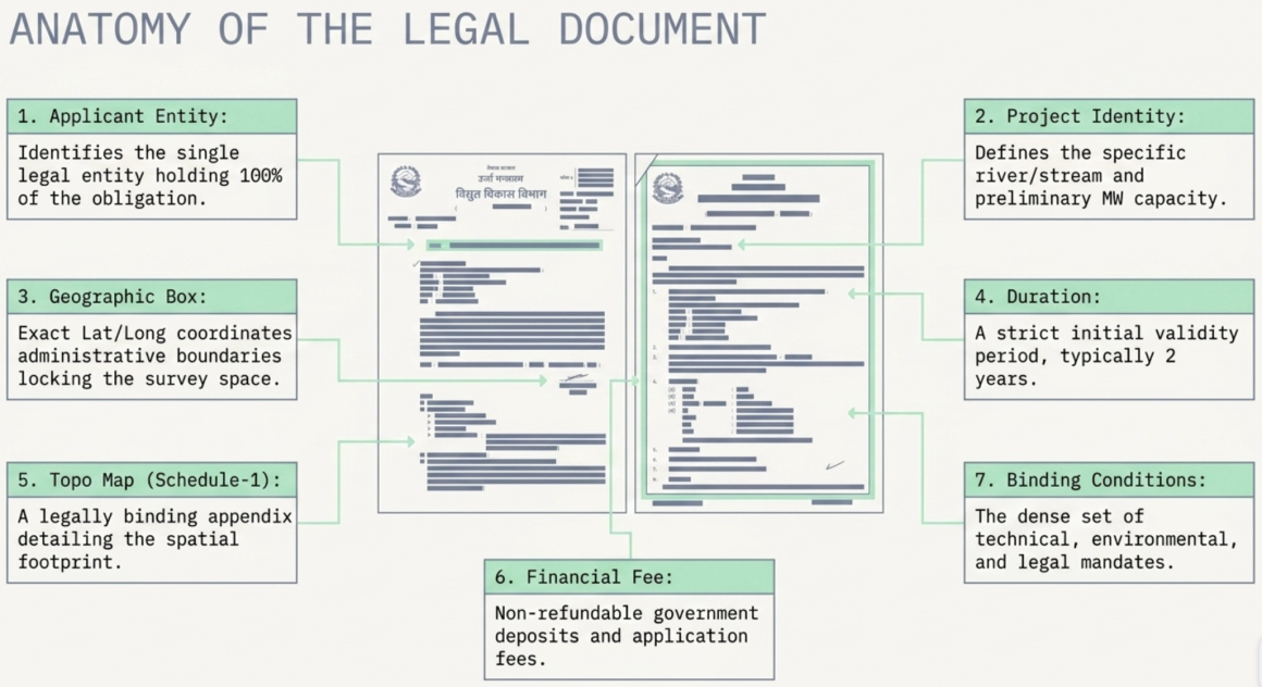
3.1 Applicant Identification
The license begins by identifying the person or organized institution that applied for and received the license, including their registered name, address, phone numbers, and email. This establishes the single legal entity that bears all obligations under the license.
3.2 Project Identification
The license specifies three critical identifiers: the type of electricity to be surveyed (typically a hydropower, in Nepal’s context), the name of the water resource (the specific river or stream), and the projected initial capacity in kilowatts or megawatts. This initial capacity figure is a preliminary estimate – more on how it is derived in the next section.
3.3 The Precisely Defined Survey Area
This is one of the most critical elements. The government locks the developer into a specific geographical box. The survey area is defined by both administrative boundaries (zone, district, and village development committee or municipality) and exact geographic coordinates – specifying the easternmost, westernmost, northernmost, and southernmost points using degrees, minutes, and seconds of latitude and longitude.
Everything the developer does – every drill hole, every river gauge, every geological walkthrough – must stay inside this box. This geographical constraint is not merely administrative; as we will see later, it carries strict legal consequences.
3.4 Nature and Duration
The license states the nature of the survey – typically “feasibility and environmental study of the project” – and its validity period. A standard initial survey license in Nepal is granted for two years, with the possibility of renewal if the developer can demonstrate satisfactory progress.
3.5 The Topographical Map
Attached to every license is a topographical map submitted by the developer with their application. This map visually delineates the project’s catchment area, the planned paths for tunnels and shafts, and the proposed locations of all major infrastructure – the diversion weir, headrace tunnel, surge tank, pressure shaft, and powerhouse. The map is not just illustrative; it is a legally binding appendix that defines the spatial footprint against which compliance is measured.
3.6 License Fee
Obtaining a survey license requires payment of a license fee and deposit to the government. Renewal also involves an additional fee. The fee structure is defined by prevailing regulations and varies by project scale. (The detailed fee framework will be covered in a separate blog post.)
3.7 Conditions
The bulk of the license document – and by far its most consequential content – is a detailed set of conditions that the developer must comply with. These conditions cover everything from mandatory study requirements and reporting obligations to prohibitions on transferring the license. We will unpack these in detail in the sections that follow.
4. Before the Survey: How a Project Gets Its Initial MW Estimate
A natural question arises: if the purpose of the survey license is to study a project’s feasibility, how does the developer already have a megawatt capacity figure on the license before any physical survey has been done?
The answer lies in what engineers call a desk study – a preliminary analysis conducted entirely from existing maps, satellite imagery, and historical data, without physically visiting the site. The two fundamental variables that determine any hydropower project’s capacity are Head and Flow.
4.1 Head (H) – The Vertical Drop
“Head” is the vertical distance that water falls from the point where it is diverted from the river (the intake) down to the turbines in the powerhouse. The greater the vertical drop, the greater the water pressure at the turbine, and the more power can be generated.
During the desk study, engineers estimate head using existing topographical maps with contour lines – or increasingly, digital elevation models derived from satellite data. They identify a plausible intake point high on the river and a plausible powerhouse location downstream at a lower elevation, and simply measure the difference. If the intake is at 1,500 meters elevation and the powerhouse at 1,200 meters, the gross head is 300 meters.
4.2 Flow (Q) – The Volume of Water
“Flow” (also called “discharge”) is the volume of water moving through the system per unit of time, measured in cubic meters per second (m³/s). Without physically gauging the river, engineers estimate flow by analyzing the catchment area – the total land area that drains rainfall and snowmelt into the river at the proposed intake point – and multiplying it by historical average rainfall data for the region.
4.3 Why These Are the Two Critical Inputs
Hydropower converts the potential energy of elevated water into mechanical energy (spinning a turbine), which a generator then converts into electricity. The fundamental physics is straightforward: power depends on how much water you have and how far it falls. If either head or flow is zero, the resulting power is zero. Finding a location with the best combination of a steep vertical drop and a reliable water volume is the absolute first step in hydropower development.
4.4 The Formula
The standard engineering formula for hydroelectric power is:
| Power (kW) = 9.81 × Q × H × e Where: 9.81 = acceleration due to gravity (m/s²) Q = Flow / Discharge (m³/s) H = Net Head (m) e = System Efficiency (decimal, e.g. 0.88 for 88%) To convert to MW: MW = kW ÷ 1,000 |
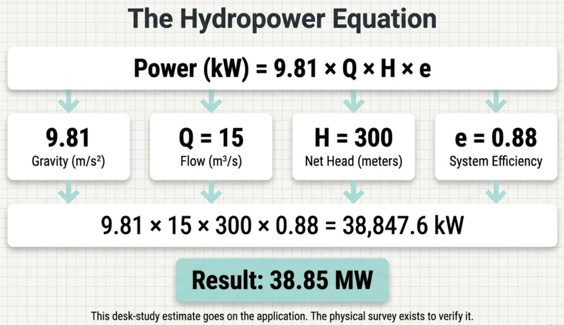
4.5 A Practical Example
Imagine a developer is evaluating a mountain river in Nepal for a hydropower project:
- Head: Topographical maps show the diversion weir can be built at 1,500 meters elevation, with the powerhouse down in the valley at 1,200 meters. The vertical drop (Head) is 300 meters.
- Flow: Analysis of the catchment area and historical rainfall data suggests the river reliably delivers 15 cubic meters per second (m³/s) through the headrace tunnel.
- Efficiency: The manufacturer estimates 88% efficiency (0.88) for the turbine-generator combination.
Step 1: Calculate in Kilowatts
Power (kW) = 9.81 × 15 × 300 × 0.88 = 38,847.6 kW
Step 2: Convert to Megawatts
MW = 38,847.6 ÷ 1,000 = 38.85 MW
This rough number – derived entirely from maps and historical data, without a single boot on the ground – is what appears on the survey license application. The entire purpose of the subsequent physical survey is to verify, refine, or correct this estimate with real-world measurements.
| Key Takeaway The initial MW capacity on a survey license is always a preliminary estimate from a desk study. It is subject to revision once actual survey data is collected. Nepal’s licensing framework explicitly allows for capacity amendments – developers can apply to revise the MW figure after the survey produces more accurate data on head, flow, and site conditions. |
5. The Mandated Studies: What the Developer Must Actually Do
The survey license is not a passive document – it comes with a strict mandate. Within the validity period (typically two years), the developer must complete a comprehensive set of technical and environmental studies in accordance with the Guidelines for Study of Hydropower Projects. These studies are not optional; failure to demonstrate satisfactory progress can result in the license being cancelled outright.
Here is what each mandated study involves:
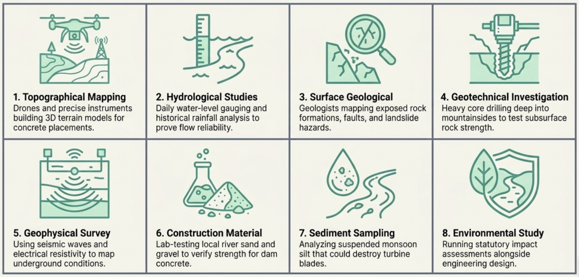
5.1 Topographical Mapping
This is the highly precise surveying and mapping of the land surface’s features and elevations. Surveyors use instruments such as total stations, GPS equipment, and increasingly drone-based aerial photogrammetry to create detailed three-dimensional models of the terrain, represented through contour lines on maps.
Example: Surveyors deploy drones across the steep river valley to build a 3D elevation model. This model allows engineers to calculate the exact height the dam needs to be, measure how much earth must be excavated for tunnels, and determine the optimal placement for access roads – all with centimeter-level precision.
5.2 Hydrological Studies
Hydrology is the scientific study of the movement, distribution, and quality of water. For hydropower, hydrological studies involve analyzing historical rainfall data, measuring the river’s daily and seasonal flow rates (discharge), and assessing the overall catchment area – the land area where rain collects and drains into the river.
Example: Engineers install a water-level gauge in the river and record measurements every day for the study period. This data proves whether the river actually has enough water during the dry winter months to spin the turbines, or whether the plant would have to shut down seasonally. Crucially, hydrological studies also calculate “flood return periods” (for example, the 100-year flood level) so that the dam and spillways can be engineered to safely withstand extreme weather events.
5.3 Surface Geological Mapping
This is a comprehensive visual and physical survey of the exposed rocks, soil types, fault lines, and landforms visible on the earth’s surface. Geologists walk the survey area systematically to identify rock formations, measure the angle at which rock layers are tilted (known as the “dip” and “strike”), and map any natural hazard zones such as active landslides or severely eroded banks.
Example: A team of geologists walks the proposed four-kilometer headrace tunnel route, examining exposed rock faces at every accessible point. They identify a fault zone crossing the planned path and recommend re-routing the tunnel alignment to avoid structurally weak rock that could cave in during excavation.
5.4 Geotechnical Investigation
While surface geological mapping examines what is visible on top, geotechnical investigation explores what is hidden underground. This involves heavy drilling machinery boring deep holes (core drilling) into the earth to extract cylindrical samples of rock and soil from depth. These core samples are sent to a laboratory to test their compressive strength, permeability, and load-bearing capacity.
Example: Before excavating a massive cavern for the underground powerhouse, drillers bore 100 meters straight down into the mountain. The extracted cylindrical rock samples are crushed in a hydraulic press in a laboratory. The test results prove whether the underground rock is strong enough to serve as the roof and walls of the powerhouse cavity without collapsing – a non-negotiable safety determination.
5.5 Geophysical Survey
Geophysical surveys study the subsurface physical properties of the earth – density, magnetic properties, electrical resistivity, and seismic wave velocities – without physically digging. Techniques such as seismic refraction and electrical resistivity tomography allow engineers to build a picture of underground conditions across broad areas, complementing the more targeted but expensive core drilling.
5.6 Construction Material Survey
Building a hydropower project requires enormous volumes of sand, gravel, stone aggregate, and other materials. Rather than trucking everything from distant quarries at enormous cost, engineers survey local sources to determine whether suitable construction materials exist near the project site and in sufficient quantity.
Example: Engineers survey the natural riverbed upstream to test whether the local gravel has the strength and gradation to serve as concrete aggregate for the dam. If the local material passes laboratory tests, it could save the project millions of rupees in transportation costs compared to importing aggregate from hundreds of kilometers away.
5.7 Sediment Sampling and Analysis
Rivers carry suspended particles – sand, silt, and debris – especially during the monsoon season. Sediment studies involve collecting water samples at different times of year to measure the concentration, particle size, and mineral composition of the suspended sediment.
Example: During the monsoon, the river turns brown with silt. Engineers sample this water and laboratory analysis reveals a high concentration of hard, abrasive quartz particles. Because quartz can rapidly erode expensive steel turbine blades, this finding forces engineers to design a larger desander (settling basin) to filter out the abrasive material before the water enters the powerhouse – a design decision that directly affects both project cost and the lifespan of the machinery.
5.8 Environmental Study
Alongside the engineering studies, the developer must conduct environmental and social impact assessments in accordance with the Environment Protection Act, 2076 and Environment Protection Rules, 2077, along with any other prevailing environmental legislation. The license requires the developer to make “significant progress” on the environmental study within the initial validity period – a deliberate requirement ensuring that environmental considerations run in parallel with engineering design, not as an afterthought.
6. The Anatomy of a Hydropower Project: Key Infrastructure Concepts
To understand what the mandated studies are actually designing and evaluating, it helps to follow the journey of water through a typical high-head hydropower plant – the kind most common in Nepal’s mountainous terrain. Each component below would be plotted on the topographical map (Schedule-1) attached to the survey license.
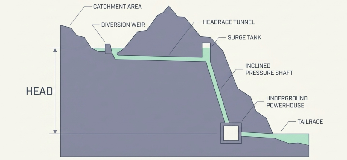
6.1 Catchment Area
The catchment area (जलग्रहण क्षेत्र) is nature’s funnel – the entire drainage basin where rainfall and snowmelt collect and flow downhill into the river at the point where the developer plans to build the diversion structure. The size of the catchment area directly determines how much water volume the river will reliably have available to run the power plant. Engineers map this area to estimate flow for the power formula.
6.2 Diversion Weir
The diversion weir is a low dam built across the river to raise the water level just enough to channel a controlled volume into the headrace system. Unlike a large storage dam, it does not create a major reservoir; it simply redirects water into the intake structure.
6.3 Headrace Tunnel
The headrace tunnel is a large, typically underground passage that transports water from the diversion weir toward the powerhouse. Instead of letting water follow the natural, gradually sloping riverbed, the headrace tunnel is drilled through the mountain at a very gentle gradient. This preserves the water’s high elevation as it travels horizontally – maximizing the vertical drop that will be exploited later.
6.4 Surge Tank
The surge tank is a vertical chamber built at the end of the headrace tunnel, just before the water drops down the steep pressure shaft. It acts as a massive safety shock absorber. If the power plant suddenly disconnects from the electrical grid, the valves at the turbines slam shut instantly. The momentum of thousands of tons of water rushing through a kilometers-long tunnel has to go somewhere – without a surge tank, the resulting pressure spike (called “water hammer”) could rupture the tunnel lining. The surge tank allows this water to safely surge upward, dissipating the destructive energy.
6.5 Inclined Pressure Shaft (Penstock)
While the headrace tunnel is relatively flat, the inclined pressure shaft is steeply pitched. This is where the vertical drop – the “head” from our formula – is actually utilized. As water plunges down this reinforced shaft, gravity transforms it into high-pressure, high-velocity kinetic energy moments before it strikes the turbine blades.
6.6 Underground Powerhouse
The underground powerhouse is a massive cavern excavated deep inside solid rock, located at the lowest practical elevation of the project. It houses the turbines, generators, and transformers – the electro-mechanical heart of the plant. Engineers often place powerhouses underground in steep mountainous terrain both to maximize the vertical drop and to protect the equipment from landslides, avalanches, and surface weather.
6.7 Tailrace
After spinning the turbines, the water exits through the tailrace – a tunnel or channel that returns the spent water to the natural river downstream.
6.8 Understanding Backwater and Tailwater
Two terms that appear prominently in the license conditions deserve special attention, because they define the true extent of the project’s impact zone:
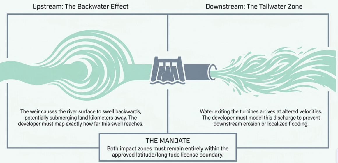
Backwater: When a dam or weir is built across a river, it does not merely raise the water level at the wall itself. The obstruction causes the river’s water surface to swell and push backward upstream for a considerable distance – sometimes kilometers. This upstream swelling is the “backwater effect.” It can permanently submerge forests, agricultural land, roads, or settlements far from the actual dam structure. The license requires developers to calculate and survey exactly how far upstream this backwater will reach.
Tailwater: After water has spun the turbines, it is discharged back into the natural river channel. This exiting flow often arrives at different velocities or volumes than the natural river flow, potentially causing downstream erosion, altered river ecology, or localized flooding. The developer must study the tailwater zone to map these downstream impacts and design appropriate energy-dissipating structures.
| Why the License Mentions Both Explicitly By legally requiring the survey of both backwater and tailwater zones, the government ensures that a developer cannot simply claim the small footprint of their concrete structure as the full project area. The developer is legally bound to study, map, and take responsibility for the entire geographical area affected by the altered water flow – both upstream and downstream – and to ensure it all remains within the approved license boundaries. |
7. Liabilities and Obligations That Attach Immediately
The moment the Secretary’s signature hits the survey license, a comprehensive set of financial, legal, and operational obligations falls upon the developer. The license is not merely a permission slip – it is a binding contract with the state. Here is what the developer is immediately liable for:
7.1 Complete Financial Liability
The license is explicit: the developer bears all costs and expenses required to conduct the survey and project studies. The Government of Nepal assumes zero financial liability or responsibility for any costs incurred during the study process. Whether the studies ultimately prove the project feasible or not, the financial risk rests entirely on the developer.
7.2 Property Damage and Compensation
Field surveys inevitably require accessing private land and property. The license allows the developer to enter private homes and land – but only after giving prior notice to the property owner. If the survey activities cause any harm, loss, or damage to the property, the developer bears absolute legal liability to pay compensation to the affected owners. There is no government indemnity or insurance backstop.
7.3 The No-Sale, No-Transfer Rule
The license contains a strict prohibition: the person or institution that has obtained the license is not permitted to sell it, transfer its rights, or transfer it to anyone else in any manner. This is not a guideline – it is an absolute bar.
To prevent indirect transfers through corporate restructuring, the license also restricts changes to the promoter company’s fundamental share structure – specifically, the investment arrangements involving the Government of Nepal, the general public, and marginalized or disadvantaged groups as proposed in the company’s founding documents. If a change to the share structure becomes genuinely necessary, the developer must present a justified reason and obtain explicit prior approval from the Ministry of Energy before making any modification.
7.4 Upstream and Downstream Responsibilities
The developer is legally bound to ensure that the proposed project does not adversely affect existing water infrastructure – both upstream and downstream. Specifically, the license mandates:
- Protection of local water resources: The feasibility study must guarantee no adverse effects on existing irrigation canals (सिंचाइको कुलो, नहर), traditional water mills (पानीघट्ट, पानीमिल), and any other water-operated projects in the river corridor.
- Coordination with other energy projects: If there are other electricity generation, transmission, or distribution projects located upstream or downstream – whether already built, under construction, or merely holding their own survey or generation licenses – the developer must identify and coordinate with all of them. The license provides that necessary details can be requested from the Department of Electricity Development.
7.5 Geographical Boundary Compliance
The entire physical footprint of the surveyed project – including the backwater zone upstream and the tailwater discharge zone downstream – must remain strictly within the geographical coordinates defined in the license. If the studies reveal that any part of the project would extend beyond the approved boundaries, it constitutes a violation of the permit conditions.
7.6 Reporting and Timeline Obligations
The developer must meet strict administrative deadlines:
- Revised work schedule: Within one month of receiving the license, the developer must submit a revised, finalized working schedule to the Department of Electricity Development.
- Progress reports: A detailed work progress report must be submitted to the Department every six months. If the Department deems it necessary, it can also require the developer to deliver an in-person presentation on progress.
- Study completion: All mandated technical studies must be completed, and significant progress on the environmental study must be demonstrated, within the license’s validity period.
7.7 Regulatory Compliance
All studies must be conducted strictly in accordance with the prevailing Guidelines for Study of Hydropower Projects, the Environment Protection Act, 2076, and Environment Protection Rules, 2077. Additionally, if the project needs to be studied in a manner different from what is described in the license, the developer must obtain prior approval from the government before proceeding.
| The Weight of the Survey License Far from being a mere formality, the survey license creates a comprehensive web of obligations. The developer assumes full financial risk, takes on legal liability for property damage and environmental impacts, surrenders the ability to trade the license, commits to protecting existing water users, and subjects itself to ongoing government monitoring – all before a single construction decision is made. |
8. After the Survey: Renewal, Capacity Amendment, and the Path Forward
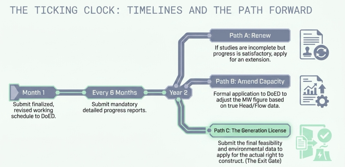
8.1 Renewal: Not Automatic, Not Guaranteed
The initial two-year validity period is often not enough to complete all required studies, particularly for larger or more complex projects in remote terrain. The developer can apply for a renewal of the survey license – but renewal is neither automatic nor guaranteed.
The renewal application must be accompanied by a report and progress details. Only if the Department of Electricity Development finds the progress satisfactory will the renewal be advanced. If the progress is deemed unsatisfactory, the license is cancelled outright. The renewal itself may come with updated conditions – including compliance with newer versions of the study guidelines if they have been revised since the original license was issued.
8.2 Capacity Amendment
Because the initial MW estimate is derived from a desk study, the actual survey data frequently reveals that the project’s capacity should be different – sometimes higher, sometimes lower. Nepal’s regulatory framework provides a formal capacity amendment process:
- Application: The developer submits a formal application to the Department of Electricity Development requesting the capacity revision.
- Supporting information: The Department may require submission of additional technical data and documentation justifying the revised figure.
- Review and decision: The Department reviews the application and supporting materials and issues an official decision.
- Notification: A formal letter notifies the developer of the approved amended capacity.
8.3 The Generation License: The Exit Gate
The survey license has a clear terminal objective: if the developer intends to actually construct the project, they must complete all feasibility and environmental studies specified in the license and submit an application for the Electricity Generation License – the permit that authorizes actual construction and operation – within the validity period of the survey license, in accordance with Rule 19 of the Electricity Rules, 2050, disclosing the details prescribed in Rule 12.
| The Hard Deadline This is a crucial point that developers must internalize: the survey license is not open-ended. It creates a hard deadline to either demonstrate feasibility and move forward toward the generation license, or lose your position. The license is a ticking clock, not a placeholder. |
The generation license application marks the transition from investigation to commitment – from asking “can we build this?” to declaring “we will build this.” Everything that comes before it – every drill core, every river gauge reading, every geological map, every environmental assessment – is the survey license doing its job.
9. Conclusion: Where Technical Reality Meets Legal Authority
The survey license sits at a unique intersection. It is simultaneously a legal instrument granting a time-bound exclusive right over a geographical area, a technical mandate requiring rigorous scientific investigation, and an operational framework imposing strict reporting and compliance obligations.
For developers, it represents the first significant financial and legal commitment in a hydropower project’s lifecycle – years of investment in studies and data collection, with no guarantee that the results will support a viable project. For the government, it is the primary tool for ensuring that Nepal’s river resources are studied responsibly, that environmental impacts are assessed before construction is even considered, and that the nation’s energy development proceeds in an orderly, coordinated manner.
For anyone seeking to understand how hydropower projects come into being in Nepal – whether as an investor evaluating opportunities, a policy professional shaping the regulatory environment, a student of energy law, or a citizen curious about the dams and tunnels taking shape across the country’s mountain landscape – the survey license is where the story begins.
This post is part of an ongoing series exploring Nepal’s hydropower regulatory framework.